Shade Tracker for iPhone & iPadSee the shadow
before you get there.
Shade Tracker draws the shadow of every building and tree onto a live map on your iPhone or iPad. Drag the timeline and watch it move — minute by minute, any date, anywhere in the world.
Free download · iPhone & iPad · No account required
Plan view of a city block with building and tree shadows drawn for 14:10. The marked terrace is currently in the sun.
A working demo: stylised block plan, real solar geometry for Istanbul. In the app the same calculation runs on actual buildings and trees, anywhere you point the map.
The app
Five screens, on iPhone and iPad.
The same calculation on both. The iPad simply shows more of the map at once.
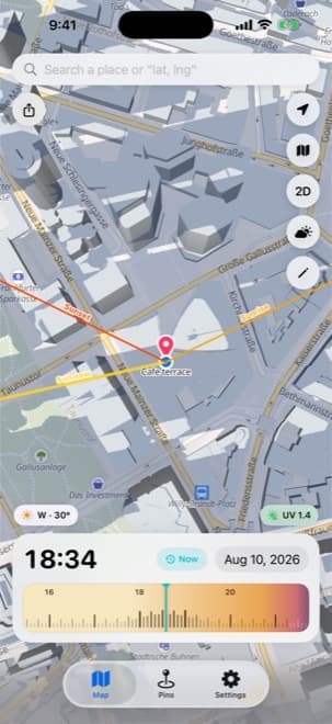
Live shadow map
Building and tree shadows at the current minute
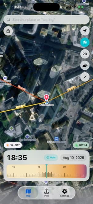
Satellite view
The same shadows over real imagery
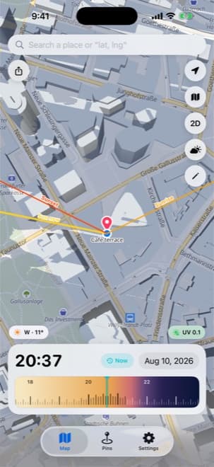
Sun direction lines
Current bearing, sunrise and sunset
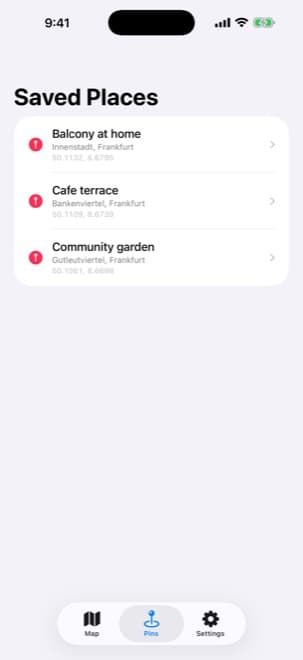
Saved places
The spots you check again and again
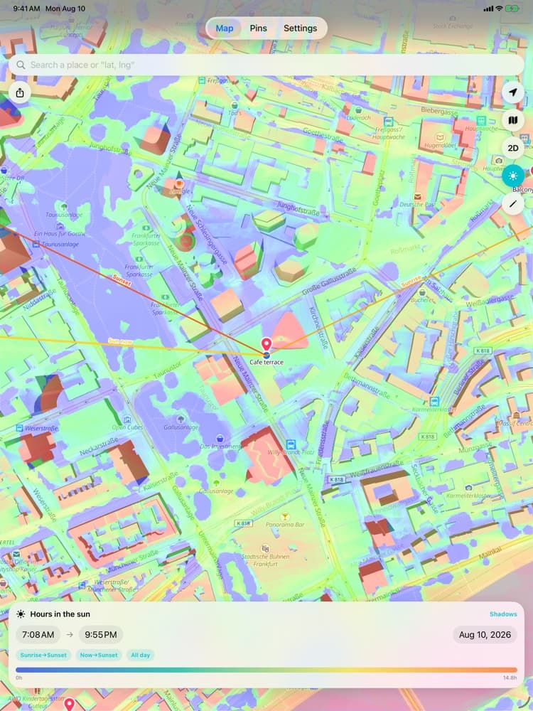
Hours of sun
A heat map of daily sunlight, read at a tap
What it answers
Nobody wants a shadow map. People want the answer to one small question.
Usually a question you can only answer today by standing there and waiting — or by guessing wrong and finding out in July.
“Does this flat get afternoon sun?”
Renting & house-hunting
“Where do I park so the car is still shaded in three hours?”
Parking in summer
“Which side of the terrace has sun at 7 pm?”
Cafés, restaurants, rooftops
“How many hours of sun does this corner of the balcony get?”
Gardening & plants
“When does the building shadow cut into my frame?”
Photo & video
“Is this roof worth panels?”
Solar & energy
“Which side of the street is shaded right now?”
Running, cycling, dog walks
“What shadow does this new block drop on the neighbour?”
Architecture & landscape
“What time does the picnic area go into shade?”
Events, weddings, picnics
Inside the app
Eight things it does, and does properly.
Live shadow map
Building and tree shadows are drawn straight onto the map, from the real astronomical position of the sun. Not just blocks — canopy heights come from a global tree model, so the shade under a plane tree counts too.
The timeline
A film-strip you drag with your thumb: 1 pixel is 1 minute, and the shadows move as you scrub. Its colour is derived from the real solar altitude of that minute, so night, twilight, golden hour and full day are visible at a glance.
Hours of sun
Turn the map into a heat map for any window — sunrise to sunset, now to sunset, the whole day. Tap anywhere to read the exact figure: this spot gets 4 h 20 m of sun today.
Annual sunlight
The same heat map sampled across a full year, for the decisions you only make once: where the panels go, which corner of the garden takes the tomatoes, whether that balcony is worth the rent.
Shadow calculator & eraser
Draw a mass on the map, give it a height, and its shadow joins the calculation immediately — in 3D it stands as real volume. Set the height to 0 and it works as an eraser: what happens if this tree comes down, or that block is demolished?
UV index
Current UV where you are, in the standard health colour bands, and the forecast for whatever minute the timeline is on. It is a clear-sky value — it does not know that you are standing in shade, and the app says so.
Saved places
Long-press a point, name it — Home balcony, Office car park, the café where we have breakfast. The address resolves itself, and one tap flies the map back there tomorrow morning.
2D, 3D, satellite & sun lines
Tilt into 3D and the buildings gain volume. Switch to satellite imagery. Turn on arrows for the current sun bearing, sunrise and sunset — each one separately, pinned to the centre of the map as you pan.
The same block, three moments
A courtyard that is perfect at one o’clock can be gone by half past six.
The timeline is the part you will actually use
It is not a slider with a clock on it. One pixel is one minute, roughly six hours of context sit on screen at once, and it scrolls as far into the past or the future as you care to drag. The colour band is computed from the solar altitude of each minute — so golden hour is something you can see coming, not something you have to look up.
Same colour mapping as the strip in the demo above.
Where the numbers come from
The sun geometry is exact. The city model is an estimate.
Both halves of that sentence matter, so here is the full list of what Shade Tracker does not know:
- In most places, building heights are estimates from open map data. Individual roof shapes are not modelled one by one.
- Tree heights come from a global canopy model, not from measuring each tree.
- The high-resolution surface mode covers selected cities only, and falls back to the standard model elsewhere.
- The UV index is a clear-sky value. It does not know whether you are standing in shade.
- Clouds and weather are not part of the calculation. The question it answers is: if the sun is out, where does the light land?
No account. Nothing to sign up for.
The shadow calculation happens on your iPhone or iPad. Your saved places and your drawings stay there too. Location is used to put you on the map — it is not sent to us, because there is no us to send it to.
Read the privacy policyFAQ
Frequently asked questions
- How does Shade Tracker work?
- It computes the position of the sun for the exact moment and place you are looking at, then projects the shadow of every building and tree around you onto the map. Move the timeline and the geometry is recalculated — the shadows you see are the result of the calculation, not an animation.
- Does it work on iPad as well as iPhone?
- Yes. It is a universal app: the same download runs on iPhone and iPad, and the calculation is identical on both. On an iPad you simply see more of the map at once, which helps most with the hours-of-sun heat map and the annual view.
- Does it include tree shadows?
- Yes. Tree canopy heights come from a global tree height model, so shade under trees is part of the result rather than an afterthought. The app can also distinguish whether you are under a canopy or above it.
- Which cities does it work in?
- Worldwide, wherever map and building data exist. The optional high-resolution surface mode — measured roof shapes, tree masses and terrain at roughly half-metre resolution — currently covers selected cities only; in Türkiye that means Istanbul, Ankara and Izmir, while central Antalya and Bursa are outside coverage. Where there is no coverage the app quietly falls back to the standard mode.
- Can I look at a past or future date?
- Yes. The timeline scrolls forwards and backwards without limit, marks the new day when you pass midnight, and you can jump to any date from the calendar. One tap on Now returns you to the present.
- Does it need an internet connection?
- Yes — map and building data are streamed as you pan. The shadow calculation itself runs on your device.
- Do I need an account? What data do you collect?
- There is no account and no sign-up. Saved places and drawings stay on your device. Location is used to show where you are and is not uploaded to us.
- Can I use it to plan solar panels?
- For a first read, yes: the annual sunlight map tells you which surfaces are lit and roughly for how long across a year. It is a screening tool, not an engineering yield report — for a real installation decision, have the surface surveyed.
- How accurate is it?
- The solar geometry is exact. The uncertainty is in the city model: in most places building heights are estimates derived from open map data, and roof shapes are not modelled one by one. Tree heights come from a global model rather than individual measurement. Cloud cover is not considered at all — the app answers where the sun lands if the sun is out.
- Can I see the shadow of a building that doesn’t exist yet?
- That is what the shadow calculator is for. Draw the footprint, give it a height, and its shadow is included in every calculation from that point on. Drawings are stored on your device and can be edited or deleted later.
Something else? Support page
Stop standing outside at 4 pm
to find out.
Shade Tracker is out now for iPhone and iPad. Free to download from the App Store.